|
Using GPS Units
Technology has come a long way in the past 10 -20 years. Most K9 Search and Rescue Teams use a GPS device to track the exact location of the areas that have been searched, marking waypoints along the trail.
What is GPS? 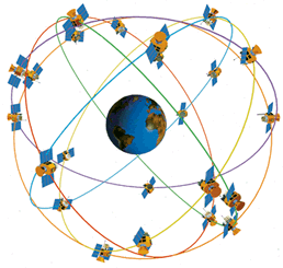
To make this measurement as accurate as possible, the GPS navigation signals are specially designed to make it easy for receivers to measure the time of arrival and to allow all the satellites to operate on the same frequency without interfering with each other. To calculate its precise latitude, longitude, and altitude, the receiver measures the distance to four separate GPS satellites. By using four satellites, the receiver calculates both its position and the time and doesn't need an expensive atomic clock like those on the satellites. This calculation is based on a mathematical principle called trilateration. Simply put, if you are "X" amount of distance from satellite A, and "X" amount of distance from satellite B, and "X" amount of distance from satellite C and D, then you must be "here". GPS uses a system of coordinates called WGS 84, which stands for World Geodetic System 1984. It allows surveyors all around the world to produce maps, all with a common reference frame for the lines of latitude and longitude that locate places and things. Likewise, GPS uses time from the United States Naval Observatory in Washington, D.C., to synchronize all the timing elements of the system.
A geocentric datum and graphic coordinate system based on the Geodetic Reference System 1980 ellipsoid (GRS80). Mainly used in North America, its measurements are obtained from both terrestrial and satellite data.) A less common datum is NAD27. (North American Datum of 1927. The primary local geodetic datum and geographic coordinate system used to map the United States during the middle part of the 20th century, referenced to the Clarke spheroid of 1866 and an initial point at Meades Ranch, Kansas. Features on USGS topographic maps, including the corners of 7.5-minute quadrangle maps, are referenced to NAD27. It is gradually being replaced by the North American Datum of 1983.) What type of GPS should I use? There is a unit for just just about any event nowadays. Choosing the one that best suits your needs can be a bit confusing. I've listed a few examples below, but there are many different brands to choose from. If you are a K9 Handler the Garmin Astro GPS is a great choice. This unit gives you all the great features with the ability to track up to ten dogs on one unit. For Garmin Products
click here.
|


